Aberdare National Park is one of Kenya’s prime protected areas; at 765.7 Square Kilometres. This Park runs the expanse of a majestic mountain range on the eastern edge of the Rift Valley.
The ranges stretch from Nairobi in the East, to Nyahururu in the West; cutting through several administrative counties.
The soil is majorly of red volcanic origin, and very fertile, with many places having huge humus pads. The park has a great stretch of alpine moorland vegetation, mainly above 3,000m.
This great landscape has led to the park’s nick-name:- “Majestic Peaks, Moorlands and Intriguing Falls”.The ranges have two main peaks namely: Ol Donyo Lesatima (3,999m) and Kinangop (3,906m).
Aberdare National Park forms a thick tropical forest, with deep ravines and dissecting riverine gorges.
At certain areas, these rivers form majestic waterfalls, which leave a sight to be desired. Karuru Waterfalls are massive and fall in three steps (the 1st step at 117m, 2nd step 26m and 3rd step 130m. In total, it makes 273m).
Another interesting one is Chania Waterfalls. There are also several other smaller waterfalls.
The ranges encompassing Aberdare National Park are a major water tower in Kenya and form the catchments for Kenya’s two largest rivers- Tana and Athi. Historically, the area is famous for forming part of the “Happy Valley”.
Even better, the Queen of England made more history here, as she entered the Aberdare National Park as a princess and left as the queen- while staying at Treetops Lodge.
The legendary Mau Mau leader Dedan Kimathi also had a hideout in the forest. All these attractions are accessible in the park.
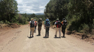
The northern moorlands of the Aberdares Ranges accessed through Shamata Gate, offer some of the best trekking in Kenya.
Very few hikers ever come to explore this delightfully isolated wilderness, with landmarks like Dragon’s Teeth, Ol Donyo Le Satima summit, and Table Mountain.
The Aberdare (or Nyandarua) mountains are an isolated volcanic range that forms the easternmost wall of the Great Rift Valley, to the east of the high Kinangop/Laikipia plateau.
They are around 160 kilometers long from north to south (the northern end almost reaching the equator).
There are two main peaks, Ol Donyo Le Satima (3,999 m) to the north and Kinangop (3, 906 m) to the south, separated by a long ‘saddle’ of land above 3,000 m. The small peak of Kipipiri (3, 349m) flanks the main range to the west, linked to it by a formerly forested valley at around 2,700 m.
Deep ravines cut through the forested eastern and western slopes and there are many clear streams and waterfalls.
The park is renowned for its torrential waterfalls plunging from cloud-shrouded heights to spray-filled ravines.
They include the magnificent Karuru falls, which drop 300m, the impressive Gura falls which torrent from the opposite side of the same Gorge, the drop of the Chania falls and the enchanting Gura falls which cascade across the yawning mouth of the Queen’s Cave.
Mist and rain occur throughout much of the year, with precipitation varying from around 1,000 mm on the drier north-western slopes to as much as 3,000 mm in the south-east.
The vegetation varies with altitude. A rich alpine and sub-alpine flora, including species of Senecio spp, Lobelia spp, Erica spp, Erica spp, Helichrysum spp and tussock grasses, gives way at around 3,000 m to bamboo Arundinaria alpine and then montane rainforest.
The peaks are open tussock moorland, with some areas resembling the highlands of Scotland.