Day 1 Nairobi – Chogoria – Mt Kenya Bandas (2,950mts)
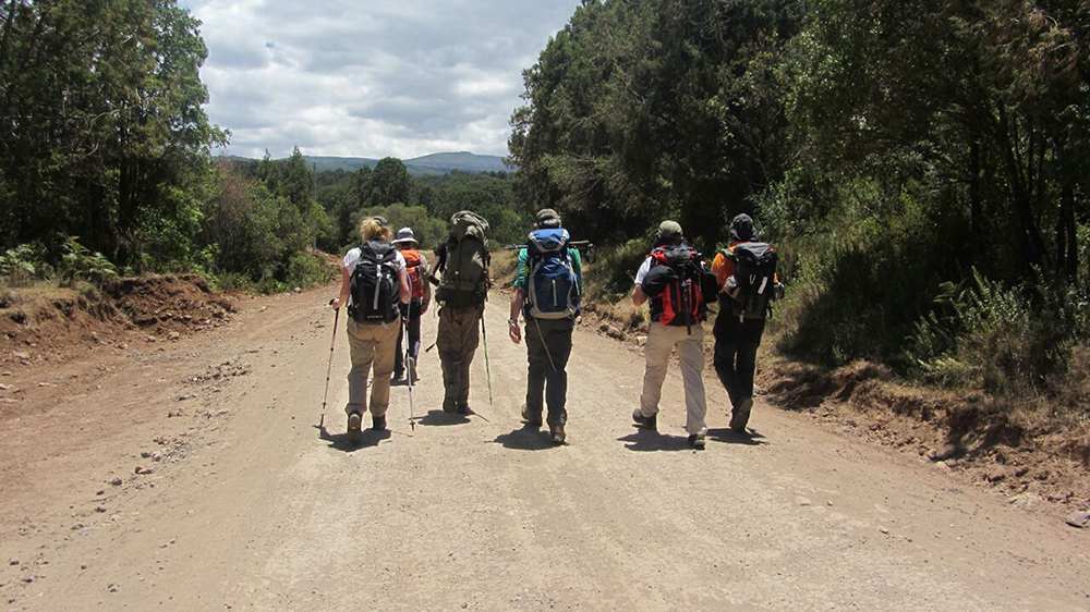
Depart from Nairobi by 08.00hrs headed for Chogoria. The drive will take you approximately 4 hrs and pass through the agricultural country. You will arrive in time for lunch (picnic). Chogoria is a small urban settlement on the slopes of Mount Kenya and it is the start of the Chogoria route.
It is here you will meet with the mountain crew (Guide, Porters and Cook). After lunch, there will be a short briefing and checking of the Luggage. The road from Chogoria village to the Bandas is rugged and you will change vehicle to the accustomed 4X4 land rovers that are more suited for the drive up.
Chogoria Bandas is 30 km from the village but the vehicle will take only 20km and walk up the other 5km. This walk helps with much-needed acclimatization. This will be a 2 hours walk through the forest and bamboo zone. You will get to the Bandas by 17.00hrs.
- Drive distance: Nairobi to Chogoria is 180 Km.
- Drive time: Drive time from Nairobi to Chogoria is 3 hours.
- Walking time: 2hrs.
- Altitude change. 2750mts to 3000mts. (Ascend 250m).
- VEGETATION: Forest and Bamboo zone.
- CLIMATE: A typical day is clear and cool in the morning with low humidity. The mountain is in direct sunlight which causes the temperatures to rise quickly with the warmest temperatures occurring between 9 am and 12 am. The temperatures on Mount Kenya fluctuate greatly. This fluctuation is largest on the lower slopes of the moorland zone. At an altitude of 3,000 metres (9,800 ft), there is an 11.5°C mean range in daily temperature, this goes down to 7.5°C at 4,200 metres (13,800 ft) and 4°C at 4,800 metres (15,700 ft). The diurnal temperature fluctuation reduces with altitude.
- ACCOMMODATION: Stay at Chogoria Bandas – 3000Mts. (Comfortable Log cabins with beds)
- MEALS: Lunch will be a picnic. Dinner and overnight will be Chogoria bandas.
Day 2: Chogoria Bandas – Roadhead (3,300)
Leaving after breakfast. The wet forest landscape opens abruptly above the bamboo zone, presenting a vista of parkland laced with magnificent stands of East African Rosewood (Hagenia abbysinica) – massive trees that are centuries old with broad trunks and a spreading umbrella-shaped crown.
Divert from the main track and trek to the base of Mugi Hill (3500m). For better acclimatization, climb the hill then descend and walk to our camp beside the Nithi River for dinner and overnight.
- Walking distance: 16km
- Walking time: 6 hrs.
- altitude change. Bandas 3000mts to Mugi Hill 3500mts then to Nithi Camp 3300mts.
- VEGETATION: Rosewood and giant heathers zone. This habitat is characterized by shrubs with small leaves. In moister sites, there are mostly giant heathers (Erica and Phillipia) which grow to over 10m and form dense stands which are virtual forests in themselves.
- CLIMATE: A typical day is clear and cool in the morning with low humidity. The mountain is in direct sunlight which causes the temperatures to rise quickly with the warmest temperatures occurring between 9 am and 12 am. The temperatures on Mount Kenya fluctuate greatly. This fluctuation is largest on the lower slopes of the moorland zone. At an altitude of 3,000 metres (9,800 ft) there is an 11.5°C mean range in daily temperature, this goes down to 7.5°C at 4,200 metres (13,800 ft) and 4°C at 4,800 metres (15,700 ft). The diurnal temperature fluctuation reduces with altitude.
- ACCOMMODATION: Stay at Nithii Camp (3200Mts). We use 2-man mountain tents with karrimats.
- MEALS: Lunch will be a picnic. Dinner and overnight will be at Nithi Camp.
Day 3: Roadhead – Mintos Camp (4,300m)
Leave the road head after breakfast and cross the Nithi River to reach the moorlands from where you can enjoy good views of the picturesque Gorges Valley, the Temple, lakes, mushroom rocks, billiards table and the high peaks. Hike for 5-6 hours to Minto’s campsite, picnic, dinner and overnight at Minto’s (4300m).
- Walking distance: 16km
- Walking time: 5 – 6 hrs.
- altitude change. Road head 3300mts to Mintos Camp 4300mts. (Ascend 1100mts)
- VEGETATION: Open tussock grassland that continues from the end of the giant heather right up to the snowline, with the plants decreasing in size and density as the altitude increases and the climate gets drier and colder. The equatorial afro-alpine zone of Mt. Kenya is renowned for its unusual mega-physic flora which results from a unique climate. Plants growing in this tropic-alpine environment have acquired fascinating adaptive mechanisms for survival with many having adopted a large and rosette form. The most spectacular is characterized by dense leaf rosettes resembling cabbages or artichokes.
- CLIMATE: A typical day is clear and cool in the morning with low humidity. The mountain is in direct sunlight which causes the temperatures to rise quickly with the warmest temperatures occurring between 9 am and 12 am. The temperatures on Mount Kenya fluctuate greatly. This fluctuation is largest on the lower slopes of the moorland zone. At an altitude of 3,000 metres (9,800 ft), there is an 11.5°C mean range in daily temperature, this goes down to 7.5°C at 4,200 metres (13,800 ft) and 4°C at 4,800 metres (15,700 ft). The diurnal temperature fluctuation reduces with altitude.
- ACCOMMODATION: Stay at Mintos Camp (4300Mts). We use 2-man mountain tents with karrimats.
- MEALS: Lunch will be a picnic. Dinner and overnight will be at Mintos Camp.
Day 4: Mintos Camp – Point Lenana Peak (4985mts) – Shiptons Hut (4200mts)
The Predawn attempt of the summit starts at 03.00 or 04.00hrs and you hike for about three hours up to Point Lenana – 4985mts. (the hiker’s summit) It is planned that you arrive in time to witness the African Sunrise as it reflects its golden glow on the Majestic peaks of Batian and Nelion over the equator.
On a clear day, you can see the snow-capped summit of Kilimanjaro miles away to the south. After celebrating the achievements descend to Shipton’s camp for breakfast and relax for the rest of the day. Dinner and overnight at Shipton’s camp (4200m).
- WALK: 10.5km
- WALK TIME: 4 – 5 hrs.
- ALTITUDE CHANGE: Mintos Camp 4300mts to Point Lenana 4985Mts. (Ascend 685mts) and down to Shiptons 4200Mts (Descend 785mts)
- VEGETATION: Above 4,000m vegetation gets more and more sparse, until around the snowline (4,500-4,700m) the only vegetation remaining is the everlasting, stunted grasses and the occasional Senecio or lobelia in the most sheltered of spots. Above 4,800m flowering plants cease to exist and only the hardiest plants that are left are lichens and mosses.
- CLIMATE: A typical day is clear and cool in the morning with low humidity. The mountain is in direct sunlight which causes the temperatures to rise quickly with the warmest temperatures occurring between 9 am and 12 am. The temperatures on Mount Kenya fluctuate greatly. This fluctuation is largest on the lower slopes of the moorland zone. At an altitude of 3,000 metres (9,800 ft), there is an 11.5°C mean range in daily temperature, this goes down to 7.5°C at 4,200 metres (13,800 ft) and 4°C at 4,800 metres (15,700 ft). The diurnal temperature fluctuation reduces with altitude.
- ACCOMMODATION: Stay at Shipton hut. (4200mts). A Mountain hut with bed and mattress.
- MEALS: Lunch, Dinner, and overnight will be at Shipton’s Hut.
Day 5: Shiptons Hut (4200mts) – Old Moses Hut (3,300m)
After breakfast, we descend down the pleasant Mackinders Valley in the shadow of the true summit of Batian; near the end of the day trek in the main trail to Old Moses Camp the descent takes about 4-5 hours.
Descent to Old Moses camp (3340mts). The descent is gentle and it offers ample time to enjoy fascinating scenery which includes the moorlands, Heather and Rosewood zones. You get to Old Moses by lunchtime
Day 6 -Old Moses Camp to Park Gate (2,650m)
Descending off the mountain is around 2-3 hours at the tree line in good podocarpus and cedar forest. We arrive at the park gate around l1100am. This is where we meet your awaiting vehicles to take you back to Nairobi or the next destination, at this point, you will bid goodbye to our guides and porters.